
|
||||||||||||||||||||||||||||||||||||
COZAD, NE - Severe thunderstorms produced an impressive dispay of various atmospheric phenomena as they moved across Nebraska and Kansas on June 10. The following is a journal of the day's chase. Times (CDT) are approximate. Photos can be enlarged by clicking on each thumbnail image. I started the day in Colby, Kansas and targeted the area just north of McCook, Nebraska, making it to McCook around noon. With plenty of time to spare, I stopped for lunch at a Chinese restaurant in town, watching storm chasers occasionally drive by out front. After lunch, it was a waiting game for storms to begin to fire along the dryline to the west. At around 1PM, I drifted north on Route 83 toward North Platte as the still-quiet dryline advanced eastward toward me. By 2PM, I could see the cell that had fired up near Sterling, Colorado and was heading northeast into western Nebraska. It was quickly becoming supercellular and was within a 2 hour drive to intercept. However, I decided to stick to my target, as the conditions at my location looked favorable - backed winds, good insolation, decent moisture, an approaching dryline and a cap that would hold off convection until mid to late afternoon. I stopped at the first west road intersection north of Wellfleet, right next to the North Platte NEXRAD dome. This position allowed for decent road options to the north, west and south if needed - and was a perfect spot to wait for the action to start. As soon as I stopped, a car with storm chasers Dr. Ken Dewey (University of Nebraska-Lincoln), Justin Turcotte, and Roger Grant pulled up. We decided to caravan the rest of the day. Over the next hour, we sat and waited - all the while admiring the Big Springs storm from a distance, but confident our target would not disappoint. Eventually, a cumulus field bubbled up and some towering Cu began to take shape, with a dominant tower becoming visible just to our southwest. Radar showed the cell coming right at us, so we stayed put and watched it for the next 20 minutes. In the meantime, another small but picturesque TCu was trying to fire to our northeast, behind the NEXRAD dome:
 The northern development fizzled, but we were getting excited about our storm to the south. An anvil with mammatus, along with lightning and a nice precip shaft were evident:
 We decided to drop south to get a closer look at the base. While we did, our storm quickly decreased in intensity, the updraft almost drying up completely as smaller rain showers started popping up to the south. We stopped to watch the disorganized mess of dissapointing clouds and see if something would ever get going. Finally, the convection began to re-intensify, with lightning activity increasing markedly. Everything looked like a big multicellular mess, however. We kept waiting. Finally, two discrete storms began to emerge from the complex - never completely separate, but enough to begin to organize somewhat. Severe warnings were issued for our storms, and we headed to the intersection of 83 and 23 near Maywood, which was halfway between the two cells. A hail shaft with a rainbow was visible to our northeast:
 We decided to keep with the northern cell which looked like it was becoming dominant, but our road options were not that good. We needed a northeast route, but our only east option was through Maywood and beyond on a very curvy 2-lane road. We had no choice but to take it to try and stay with the updraft. We encountered the most vivid rainbow I have ever seen just east of town. It was almost blinding to look at.
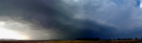
  We had a hard time keeping up with our storm due to its fast motion to the northeast coupled with the meandering roads. Near Moorefield, south of Brady, we chased what appeared to be an RFD gustfront leading north to a lowered area. Motion was turbulent but I could not confirm rotation. Saw several storm chasers here, including David Drummond who stopped to talk briefly. New cells were exploding to our south, with a precip core very close to the south, so I knew our storm did not have long before its warm inflow was history. Structure was impressive, however:
 Despite the fact that our storm was about to ingest updraft-killing rain-cooled air, we had no other players in the area - so we wanted to stay with it. We continued east, then north at Farnam toward Gothenburg. Before reaching Farnam, a large dust cloud appeared to our south -clearly due to strong outflow from the southern storm. We were soon hit with very strong south winds amidst a cloud of dust and flying tumbleweeds. We would have hoped that this was strong inflow into our storm, but alas, it was cold - not to mention having a clear gust front kicking up dust as it approached. Upon emerging from the depths of the canyon along Route 47, all we saw was low, turbulent clouds amidst cold, northwesterly outflow from what was left of our supercell. A distinct hail roar was audible to the north inside the core. Eventually, sunlight broke through, creating rainbows and sun rays amidst the scudfest for the next hour.
 
 Our last stop as a caravan was the Burger King in Cozad, and after a quick dinner we parted ways. I stayed in the Cozad/Gothenburg area shooting video and stills of an amazing lightning show for the next few hours ( RealVideo clip, 3MB ).
   
Spent the night near Kearney, preparing for a long drive to Iowa the next day. All in all, the sky put on quite a show, making for a nice chase despite the lack of tornadoes. NEXT EVENT: Tornado day in Iowa on June 11
GO: Home | Storm Chase Logs | Photography | Extreme Weather Library | Stock Footage | Blog
Featured Weather Library Article:
|
||||||||||||||||||||||||||||||||||||


Web Site Design and Internet Marketing by CIS Internet