 Another run to Kentucky (but a better show back home): April 10, 2009 Another run to Kentucky (but a better show back home): April 10, 2009
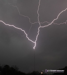
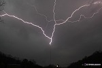
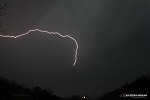
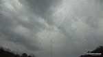
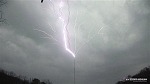
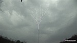
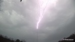
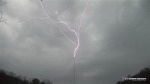
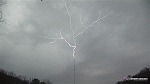
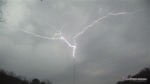
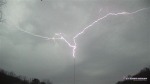
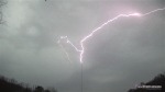
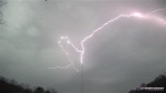
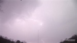
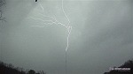
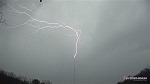
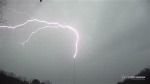
ABOVE: Upward (ground-to-cloud) lightning repeatedly hits the WVAH-TV tower near St. Albans on Friday evening.
EXPEDITION VIDEO: 10 strikes in 35 minutes to the WVAH tower: Watch Video
Click any thumbnail on this page to view a larger version.
Mt. STERLING, KY / ST. ALBANS, WV - One of the reasons I let the habit of posting these 'chase report mini-messages' lapse is that I was running out of stuff to say. I don't like trying to manufacture something important to say if it's not really on my mind. I could never be a preacher, I don't know how they can come up with messages and deliver them with enthusiasm every time. That's just not in me - I guess that's why I'm not a preacher. Which, by the way, actually gives me something to say for this chase log. A lot of people think that becoming a Christian means you either a.) join a monastery/convent, b.) give up all the stuff you like to do, c.) become a minister/preacher/missionary/church officer, etc. To be honest I actually shudder at the prospect of doing any of those things myself. I have been a Christian for over 16 years, and the closest I came to any of that was becoming a deacon in a church for a short time. I have to admit, I did not feel like that was where I was supposed to be at all. It is a very priveleged position to be in (both from a scriptural and human standpoint), but I never felt comfortable with my place in it.
I have always felt that my place in 'ministry' is right here in what you are reading now. The Lord may change that at His discretion sometime in the future, true, but for now, I know this is where I'm supposed to be. It has been fruitful in bringing people to Christ. And it involves doing something I love - chasing and photographing storms. That flies in the face of the notion that God always wants to take away all of the fun stuff in life for His followers. God wants to use you the way you are, your talents and personality are things to embrace as a Christian, not give up! We are made the way we are for a purpose. He does require sacrifice in some areas sometimes, and I've had plenty of that over the years. Not as much as has been required of some Christians, and for that I am both humbled and grateful. If there is any point to this 'mini message' is that God takes care of His own. He doesn't saddle you with more than you can handle and doesn't make life miserable and boring. So, I encourage you to check out the message. (link goes to John MacArthur's web site).
So, on to the chase. A second trip to Kentucky in less than a week makes it look like I'm back to my pre-2007 'chasing everything' habit. Not really, though. I figure I ca chase any decent tornado risk that pops up in Kentucky and Ohio, and any major risk within a day's drive - at least as long as gas stays around the current price. A trip to Lexington costs about 35 dollars at $2/gallon - not bad at all. If I make just one video sale in 3 or 4 of those trips (realistic even with the current state of the business), I've recovered the fuel cost plus the wear on my truck. So it's more than justifiable. If gas goes back up, then that will change.
I actually had good expectations to see a tornado on Friday. I felt that the biggest risk was south and east of Nashville, but the problem there is that the Appalachian terrain starts being a detrimental factor for safe chasing. So, I decided to focus on the surface low moving into eastern Kentucky. Some clearing for instability was taking place, and I thought that any isolated storm that went up in that vicinity would have a decent chance for tornadoing. Veteran Plains storm chasers may laugh at that statement, but a look at climatology reveals that Kentucky has more than its fair share of chaseable tornado events. Central Kentucky terrain isn't great, but it's better than southeastern Oklahoma and southern Missouri (and I've traveled in those areas before). Plains storm chasers tackle those difficult areas all the time if the setups happen there - so for me, Kentucky is no different. It's close and an easy drive. I expect if I'm able to cover most setups in Kentucky and Ohio, I'm eventually going to bag a nice event.
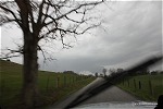
So, I left Charleston just after noon, and hit the first storms on the warm front near Morehead. Very high-based, but with some photogenic rain curtains, outflow features and flat updraft bases:
 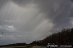 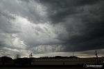 
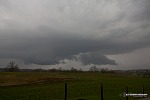
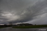
These cells continued to grow to the south of I-64, and were soon severe-warned for hail. They were not the main show, so I didn't hang around. Better storms were moving up to the south of Lexington, on course to cross I-64 near Mount Sterling/Winchester. There were two cells, a more elongated one with intermittent rotation markers approaching Mt. Sterling, and another more 'classic' looking cell to its south with persistent rotation markers. The southern cell became tornado-warned as I exited I-64 at Mount Sterling. Here is my view of the northern storm just west of Mt. Sterling:
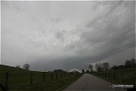
I was more interested in the southern storm, which at the time had no competing storms to its south. I reached it about 7 miles south of Mount Sterling on a rural road, cresting a hill to finally get this view:
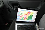
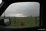
At the top of this little hill, I pulled over. Here is a radar grab at this time. My location is just east of the rotation markers (no GPS marker on this thanks to Delorme Serial Emulator not working in Vista!):
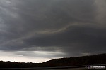
And the view to the west-southwest (see, Kentucky is not all that bad!):
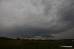  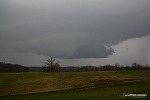 
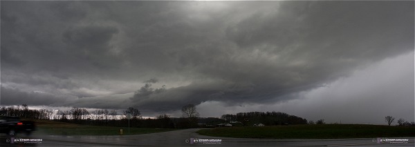
Despite how good that may look, I could not see any rapid rotation. WxWorx had rotation markers on this though, the strongest being a 92mph shear marker. The most likely center of circulation would be on the left side of that more blocky lowering (wall cloud), but again, I didn't see anything to get exited about. The 'wall cloud' developed a 'crease' of translucence on its top, where I would expect a wall cloud to be seamlessly connected to the cloud base. This leads me to believe that this, even if it may have started out as a wall cloud, was transitioning to more of an outflow/shelf cloud feature. Notice the heavy precip to the south (also visible on radar) which would also be killing any chance for this to develop further. My winds were out of the northwest at this time.
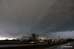
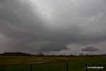
The precip to my west was about to slam me at this point, so I decided to bail to the east to 1.) avoid the hail and 2.) get a view of the southern end of the new convection to the south, which had now developed a weak shear marker on WxWorx. This was the view of the storm to the south after driving east about 4 miles:
I headed southeast on US 460 and got into position to view the southern storm near the small town of Jeffersonville, southeast of Mount Sterling. The storm looked interesting and dramatic, but no structure of any significance, other than just looking cool:
5-frame panorama stitch. A little bit of a vault to the right:
Convection was beginning to fill in everywhere, cutting off any chance for my storm to do anything. There was a new storm to the south that was looking good, staying persistently isolated with shear markers. However, intercepting it would be difficult as I had no easy road options. I was already on the western edge of the Appalachian foothills, so terrain and road 'curviness' was getting worse the farther east I went. I didn't think it was safe to try to intercept the southern cell on wet, curvy roads, so I chose to retreat back to I-64, turning north at Frenchburg toward Farmers. I wasn't that optimistic about the storm doing much anyway, but I figured I'd rather take the safer play of catching it on I-64 to the east. No need to take unecessary risks, even for a tornado. By the way, that's yet another example of many in my photography career of how the roads are more dangerous than the storm. I was not worried about the storms doing anything to me, but the danger of a wreck on slick, winding roads was very real and deserved strict attention.
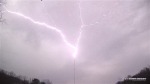
I made it to Grayson well ahead of the storm, so I stopped for a quick dinner (I hadn't eaten since morning) and to take a closer look at data. The southern storm was weakening, and everything was turning into a big mess of stratiform precip. That ends the tornado chase, but begins the tower lightning play! Electrified stratiform means great upward tower lightning, so I started the trek back to Teays Valley, arriving at the WVAH tower well ahead of the remnant storms. I love being as close as I can get to these discharges, but I decided I wanted a more distant vantage point this time - close enough to keep the bolts 'vivid' and sharp, but distant enough to get more of the discharge structure in the sky. I chose a subdivision access road off of Poplar Fork Road, about a mile away from the tower.
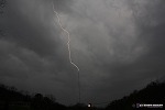
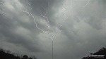
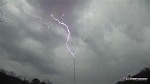
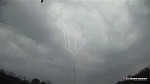
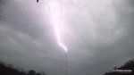
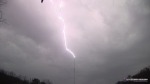
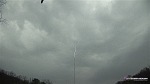
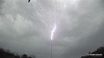
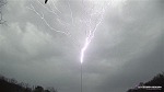
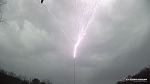
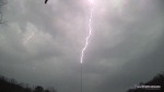
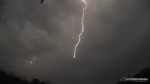
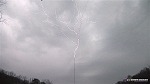
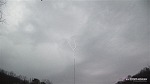
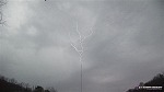
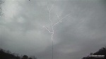
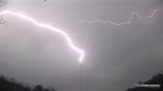
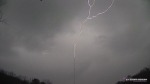
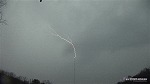
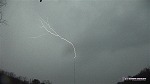
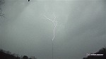
Lightning in the remnant stratiform was intermittent (only a flash every 2 to 4 minutes), but I knew that every one would pull a bolt up off the tower. That's exactly what happened. I predicted that I'd see 5 or 6 hits to the tower based on the size of the storm and the speed that it was moving. I ended up with ten! Before this I have never successfully captured what I call 'slow positive' upward lightning, which features extensive low-level upward branching. The more common 'fast positive' has a single, unbranched channel going up into the clouds, and I have plenty of shots of those (see my Lexington tower shots from last year for examples of fast positive tower lightning). For some reason I have never been able to capture good shots of slow positive discharges, until now. Some of the up-close sessions I've done may have been slow positive, but being so close, I didn't have a view of what was happening up higher.
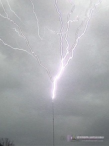
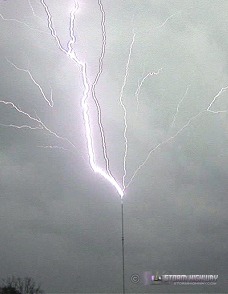
Anyway, Friday was a 'slow positive' upward discharge bonanza! I shot both HD video (click to watch video in HD) and digital stills, and was very happy with what I was blessed with. Since it was still daylight, I used short exposures (1/6 second at F8) and manually reacted to flashes with the shutter release. You can hear my camera shutter on the video, to get an idea of how good (or bad) my reaction time was. Using this method, I captured stills of 5 out of the 10 strikes:
 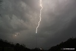  
Just barely caught the bead-out of these two:
The video frames really show the 'slow positive' branching structure and behavior the best. I divided these into sets for each discharge that you can click through to see the sequences (discharges #7 and #8 were too rapid and overexposed, and didn't have enough frames for a sequence). Just click on any thumbnail and use the links at the bottom to advance the frames:
Discharge #1
Discharge #2
Discharge #3
Discharge #4
Discharge #5
Discharge #6
Discharge #7
Discharge #8
Discharge #9
Discharge #10
I arrived home at around 9PM, not bad for a chase that started after noon.
GO: Home | Storm Chase Logs | Photography | Extreme Weather Library | Stock Footage | Blog
Featured Weather Library Article:
|


