|
Home | Blog Index | Blog Archives | Christianity & Faith Essays | Storm Chasing Essays
March 2024 Storm Chasing Recap
The first half of March was active in the Midwest, with several good supercell and lightning days close to St. Louis.
March 2024 Event List
 March 1: Sleet and snow in the St. Louis metro area March 1: Sleet and snow in the St. Louis metro area
Temperatures were in the upper 30s as the precipitation would arrive this morning, but dewpoints in the teens meant that wet-bulbing below freezing was possible at some locations. I went out for a couple of hours from New Baden to Marine monitoring road conditions and temperatures while occasionally sending in MPing reports. The precip type began as sleet, changing back and forth through the spectrum to sleet and finally snow. As expected, wet bulbing lowered the temperature as precipitation fell, cooling the surface temps to 34°F. While I did not locate any icing on elevated objects like guardrails and road signs, my car was icing efficiently on the mirrors, front grille and wipers. I did not observe any road impacts.
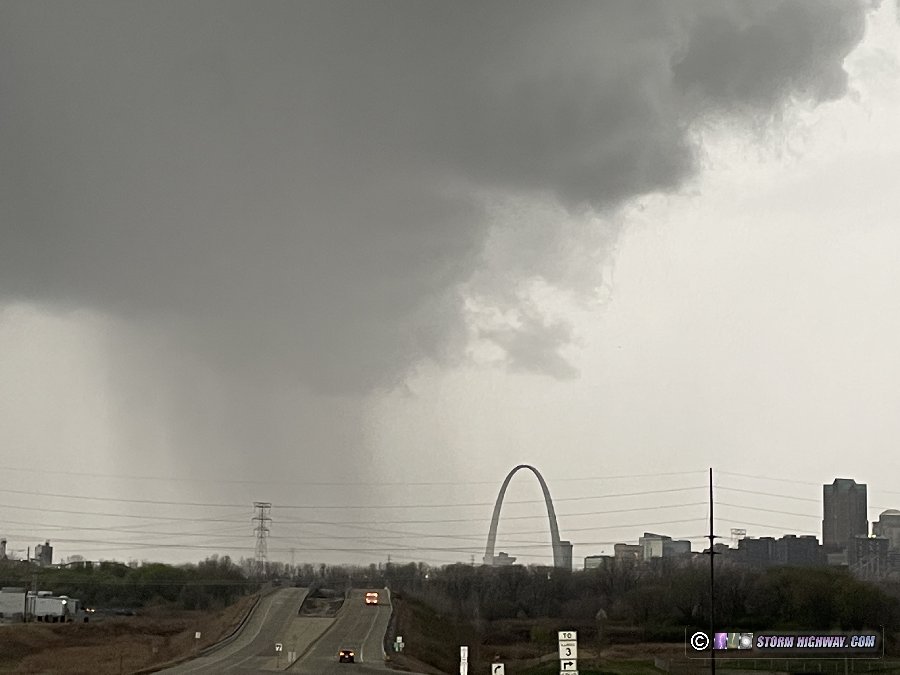
 March 5: St. Louis metro early morning lightning March 5: St. Louis metro early morning lightning
I left at 10PM on Monday night (the 4th) for what I expected would be primarily a lightning shoot, one that models had starting before midnight and peaking at dawn. Storms stayed far away from me the entire time, producing a few distant but spectacular bolts-from-the-blue at completely random and unpredictable intervals. I didn't catch any lightning channels in frame until 4AM when a storm became active near Wentzville and moved northeastward toward Jerseyville. Models had been insistent on storms blooming around the metro area at 5AM, possibly over downtown St. Louis - so I didn't want to stray too far away from the city. I shot the Jerseyville storm from near Glen Carbon while fighting the spring's first mosquito swarms, capturing a few distant shots.
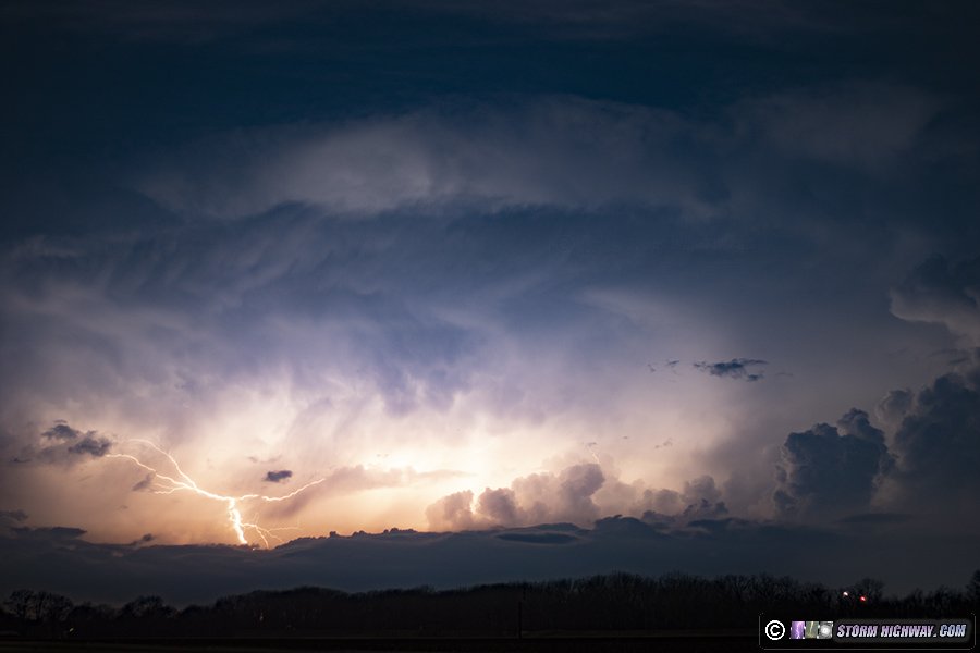
A new area of cells threatened to develop upstream of the city, so I headed downtown to await their arrival. These cells eventually dissipated. I headed east to back home in New Baden where I'd have a good 360-degree view of new development that was beginning to increase, just as models had indicated. The lightning at first was sporadic and uncooperative, until a new cell went up about 5 miles to the south of town. This storm produced a quick burst of cloud-to-ground bolts to my south in the morning twilight. In a reversal of the night's trend, I captured the best bolts - clear-air ones out of the heavy rain core (though one was right on the edge of the frame) as I-64 traffic streaks by in the foreground.
 March 8: Addieville, Illinois squall line March 8: Addieville, Illinois squall line
I was originally not planning on doing anything more than walking outside my front door to look at this weak but convective line of showers moving through the St. Louis metro. Wind fields were marginally supportive of supercells, but there was no instability available. Nothing in the area was producing lightning, so these weren't even thunderstorms - technically only rain showers. Nonetheless, when they arrived, the convection had separated into individual cells with motion in the cloud bases faster than I'd expected. There even seemed to a hint of RFD developing on the cell moving through town, which was interesting enough that I grabbed my cameras and headed east on Highway 161 to stay ahead.
The New Baden/Albers cell weakened, but a stronger area of cells was approaching Okawville. I dropped south at Bartelso to get ahead of these. The cells congealed into a line as they approached, and there wasn't any of the semi-interesting features that the cell at home had, nor any lightning. I snapped this image before heading back home.
 March 13: Ruma and St. Libory, Illinois supercells March 13: Ruma and St. Libory, Illinois supercells
This was another day with supercell and tornado potential from Kansas through Missouri into Illinois. If you've read my site for very long, you already know where I targeted: if there is any tornado potential in the St. Louis area, I'll stay here rather than drive many hours away, even if the distant target is better. While the Kansas triple point/dryline bulge looked very good (and it did produce), the local target here was not bad at all itself. Models agreed on multiple supercells firing during the afternoon right in or near the St. Louis metro area, and our environment looked sufficient for something interesting to happen: good upper support and great turning-with-height in the low levels. Our main limiting factor was dewpoints only in the 50s.
I had started building my new hail shield rig on Tuesday, hoping to have it completed for this two-day chasing interval. But it took me longer than I'd anticipated, and that work went into Wednesday. Models originally pointed to Wednesday's storms firing at close to 7pm and farther northwest near Wentzville, but an agitated cumulus field south of St. Louis at 3pm indicated that not only was the new target right at home, but I'd not have as much build time today as I'd thought. I finished what I could and got on the road just as the first storms fired to my southwest. I could even see them from home - not bad when the target storms are that close!
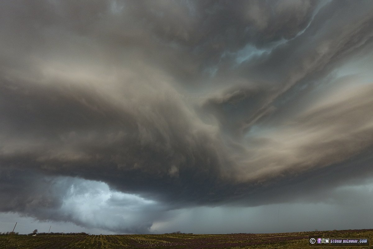
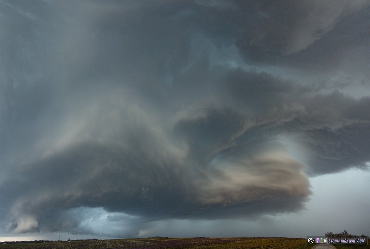
I had an easy intercept course to the first storm west of Fayetteville, but it vanished by the time I arrived on it. The next storm in the line was approaching Ruma to the south, so I headed that way, arriving in plenty of time to my observation point just south of town. I passed through nickel size hail on the outskirts of the core in town. The storm was moving slowly enough that I was able to stay at this spot for quite a long time as it approached. The storm took on some nice structure, with a rounded base and some striations appearing alongside the vault region.
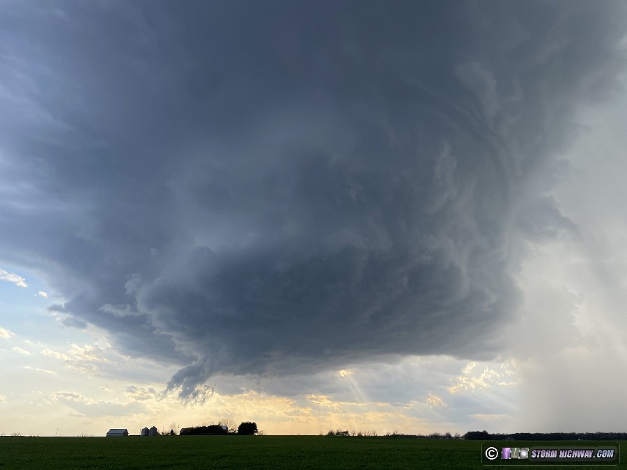
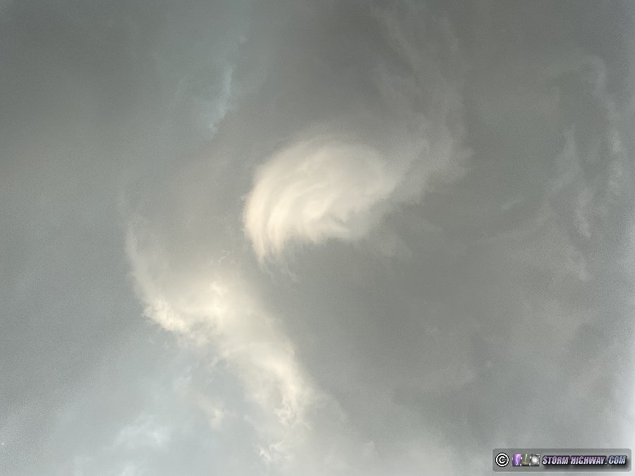
An RFD surge began shortly after this image, and strong differential motion was commencing at cloud base. As this passed directly overhead of me, a strong and persistent circulation developed. This was the view looking straight up:
About 30 seconds later, the southerly winds at my location rapidly increased, then suddenly shifted to very strong westerly RFD. The power poles along the road began to lean slightly as the wires were pulled hard to the east. Dust and small leaf debris started kicking up a few hundred feet to my north. I jumped in the car and moved south to get out of the way of the power lines in case they fell. My rear dashcam shows a potential small circulation in the field kicking up dust, but it's inconclusive if this was a tornado or just the RFD winds.
I got back on Highway 3, heading east to Evansville and then to Sparta to re-intercept the storm. It was clearly losing strength by this time, with the updraft shrinking. I had a nice view of the LP-like structure from Sparta:
As my storm continued to shrink, I turned my focus to new storms back to the west near Waterloo. I moved north to get in front of this at St. Libory, at which time a nice wall cloud formed for about 10 minutes at sunset while the storm was still about 20 miles to my west:
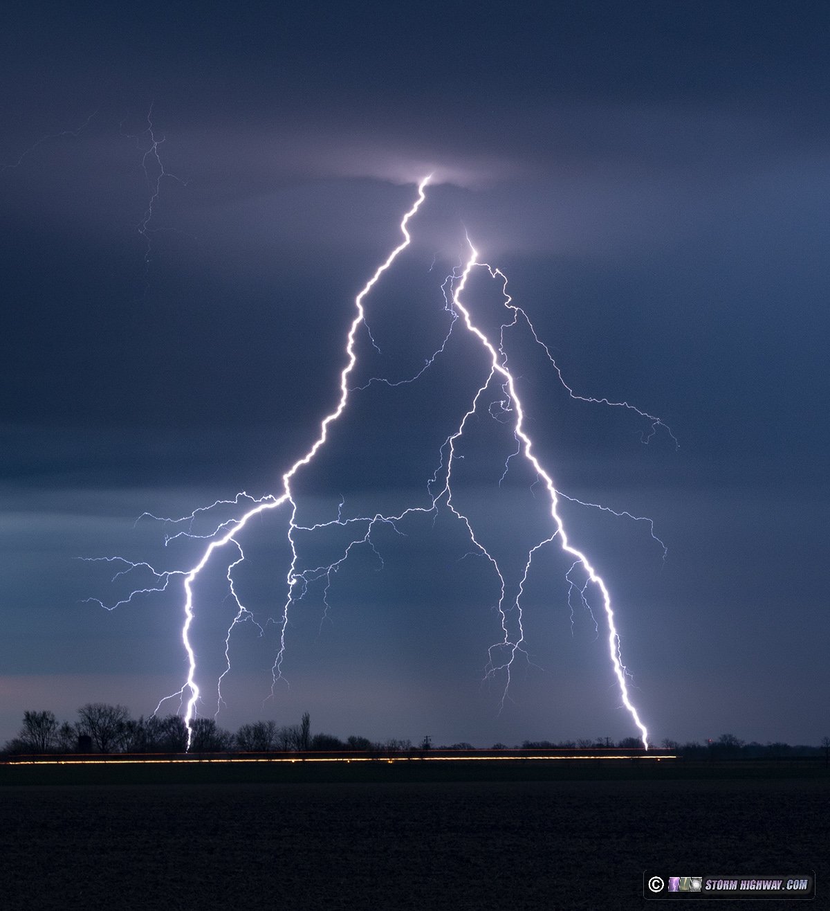
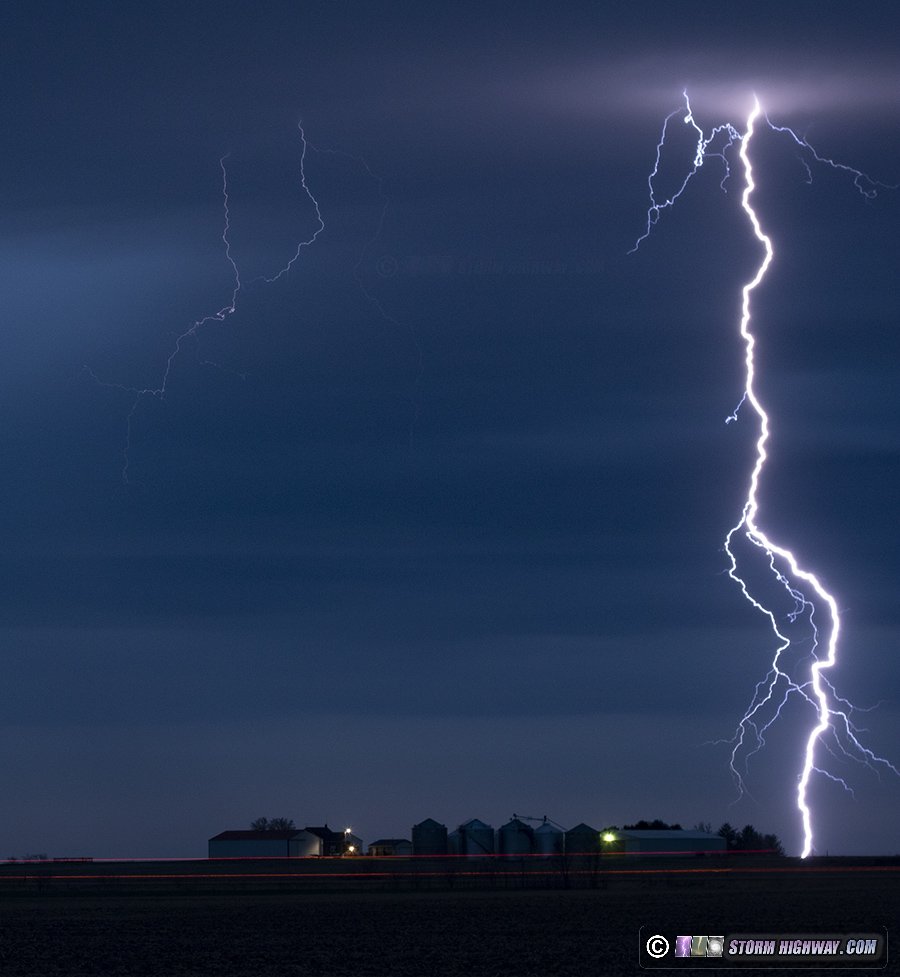
This storm also started a long weakening phase as it approached me. I moved up to New Memphis to shoot some of the nice lightning it was producing, but frustratingly I left my lens on autofocus, resulting in the shots being slightly out of focus. I did capture one of these channels on 6,000fps high speed, though.
The storms continued their weakening, with the nearest active storms being all the way west of the metro, past Wentzville. Models hinted that these would also weaken, and radar trends seemed to support that - so I didn't go after them. I ended my chase day not long after dark. March 14: Red Bud, Nashville and Okawville, Illinois supercells
Day 2 of this Midwest severe weather sequence would see supercell and tornado potential once again present in the St. Louis metro, and again would preclude any idea of me traveling outside of the area for storms. The chase day started early for me. At 7AM, I got on the road headed west for a line of morning storms approaching the city. I originally planned to do the normal thing of catching the leading cores in the city, then setting up to shoot upward lightning in the trailing stratiform region.
But as I got to within 10 miles of downtown, tornado warnings started firing off for QLCS circulations in the line just north of the metro area. I briefly entertained diverting north to intercept them, but feared that I'd be cutting it too close to be able to beat them to their I-55 crossing points. I also figured they might dissipate by then anyway as QLCS circulations often do. So, I chose to let the QLCS action go and continue to downtown.
The leading cores were uneventful, with no lightning and not much of any structure to be seen.
I didn't stay downtown, going immediately to set up in Brentwood for upward lightning. There was absolutely no lightning in the trailing stratiform region. After 30 minutes without seeing a single flash, I headed back home.
I spent the rest of the morning and early afternoon finishing up the hail shield build (a blog post will come eventually on that, in the meantime, I posted about it on Stormtrack) while simultaneously keeping track of how the main severe weather event would evolve. The morning squall line would be producing an outflow boundary that was forecasted to stall to our south, then slowly lift back north potentially into the metro area by late afternoon storm time. This would be the most favorable location for tornadoes. However, models also indicated numerous supercells firing areawide.
By midafternoon, cumulus was building up on the outflow boundary situated roughly from Festus to Red Bud, and soon, storms began to fire just southwest of there. So, I headed out, going down the same roads I'd just taken the day before to get to Ruma. The lead storm crossing the river and heading for Red Bud quickly went supercellular and looked like an obvious target. But now there was a new complication.
A storm that had fired earlier near Columbia, Missouri had evolved into a very healthy and classic-on-radar supercell and was turning hard right just south of I-70 west of Wentzville. It looked like it could potentially go right through the heart of the St. Louis metro area. Surface winds in the immediate metro were weak and badly veered (southwest) so it looked very much like that storm would have difficulty producing a tornado. The outflow boundary supercell looked much healthier and should be much more favored for tornadoes, but it seemed to be having issues with parasitic storms on its southwest flank. Do I go back for the low-tornado-threat St. Louis metro storm, or stay along the outflow boundary for a much higher tornado risk? I stopped at Freeburg for a full 20 minutes debating this decision.
After watching the St. Louis supercell seem to struggle on reflectivity and have very weak to nonexistent couplets on velocity - followed by new storms going up just ahead of it that would interfere with its inflow (not favorably positioned for merger-enhanced intensification), I made the final choice of staying with the outflow boundary storm. I arrived on the Red Bud storm to find some dramatic structure - probably the best I've seen locally.
A strong RFD was surging in, but the main meso was disorganized with very little in the way of lowerings or visible rotation. An old meso to the west appeared much more active, so I drove west to take a look. Low-level motion was weak with this feature, though, so I abandoned this and decided to get back ahead to see if the next cycle would be more fruitful.
I had considerable difficulty getting back ahead of the storm, as it was moving northeast at a good clip, at least 45mph. Structure was dramatic as I made my move east and north, with frequent tall positive CG lightning in the vault region. I caught up to a new meso briefly north of Marissa, but almost immediately was overtaken with heavy precip before I could get a good look at it. I struggled to get ahead of the storm, going all the way to Nashville before finally getting out of the rain! By this time, the storm had weakened considerably with the trailing storm to the southwest looking like the next player. So, I continued east to Ashley, preparing to drop south to intercept.
As soon as I made the turn south on Highway 51 east of Ashley, the next radar update showed that storm weakening also. Meanwhile, back in St. Louis, numerous new storms had gone up and a stratiform region was approaching the metro from the southwest. I decided to just call the supercell/tornado chase and go back into the city for upward lightning. On the return trip on I-64, I passed through another marginal supercell (elevated with no tornado potential) at Okawville.
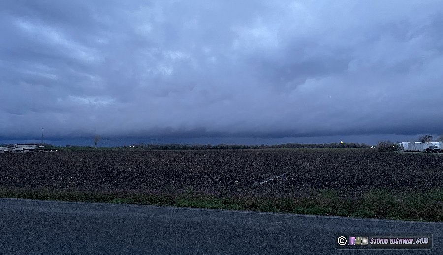
I arrived at my Brentwood location for upward lightning with the last light of the post-sunset sky peeking through the back edge of the cloud deck to the west. The stratiform region was directly overhead now, but there was no lightning propagating through it - all lightning was confined to the cores to the distant south and east. Notwithstanding, I kept shooting until the stratiform region was completely east of the area (I know better than to turn my back on such a situation!). I packed up and headed home, ending the chase day at 9PM.  March 26: Cold front arcus at New Baden, Illinois March 26: Cold front arcus at New Baden, Illinois
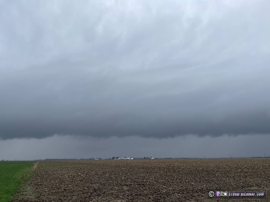
Some showers along a cold front moved through the metro area this day. This was a zero-mile on-foot "chase" as I walked out to the road to watch the arcus along the front move overhead.
 March 31: Northeastern Missouri blue-sky bust March 31: Northeastern Missouri blue-sky bust
Models had been wavering all day on a supercell forming on a secondary warm front slowly lifting north through central Missouri, tracking to across the Mississippi River around Hannibal/Bowling Green. The supercell and tornado environment along this boundary was excellent, but a strong cap would likely keep storms from forming at all. Despite the slim chance of a storm, the enviromnent was good enough (and close enough) that it was worth going just in case that storm did fire.
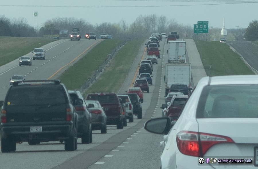
I'm not a fan of driving on Interstate 70 in Missouri during the day. The highway is far over its capacity, and slower drivers often hold position in the left lane without getting over into the gaps in between cars on the right (to allow faster traffic to pass). The result is miles of clogged left-lane congestion keeping the average travel speed below the 70mph speed limit. It's bad enough that I always plan any transit of this highway during the overnight hours when I'm heading west into the Great Plains.
I braved the traffic west to my initial staging target of New Florence as an agitated cumulus field developed along the boundary overhead. The most likely location for a storm was where instability was greater just to the west - but I wanted to keep the eastern part of the boundary within easy striking distance if a storm went up there.
Dring this time, a long-lived supercell to the north along the Iowa border was racing east-southeast toward a more diffuse warm front to the north. This storm was elevated (not rooted at the surface, so unlikely to produce tornadoes) but had a good presentation on radar. I could see the top of this storm from my location along I-70. I could easily intercept it at that point, but I didn't want to leave my target environment in case my preferred storm did go up.
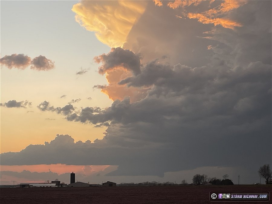
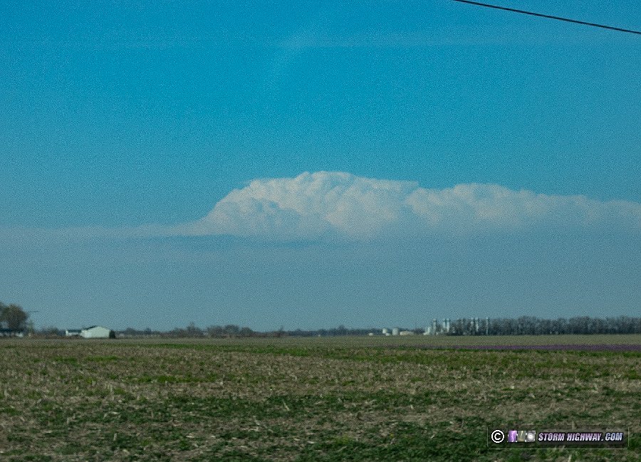
By 4PM, the cumulus field along my boundary was fizzling, despite what appeared to be some upper-level support arriving (judging from some high cirrus streaming overhead). To my distant north, some weak convection appeared to be attempting to fire, in line to track somewhere near Hannibal. So, I decided to move up to Bowling Green in case this activity could get going. Models were not optimistic that it would, and the mushy appearance of the cloud tops seemed to support that. As I moved northeast toward Bowling Green, I took the only storm photo of the day of the northern supercell as it was crossing the Mississippi River into Illinois:
The struggling cells west of Hannibal eventually weakened, as did the cumulus field along the entire boundary. The northern supercell was still possibly within reach, but I'd need to race east all the way to Decatur, Illinois to barely catch it. I didn't think that valiant attempt would be worth it, so at 5:30PM, I decided I was done for the day and headed back home.
< February 2024 Recap | All Storm Chase Logs | April 2024 Recap >
GO: Home | Storm Chase Logs | Photography | Extreme Weather Library | Stock Footage | Blog
Featured Weather Library Article:
|


