| OFFICIAL NOTICE to all El Reno tornado documentary producers and video reposters: PLEASE READ. |
Click any thumbnail on this page to view a larger version.
EL RENO, OK - This was by far the most significant event of my career, and not in a good way. This was the closest true brush with disaster I have had with a tornado, and the first time a storm has both directly injured me and (aside from hail dents) damaged my vehicle and equipment. I sustained about $2,000 in damage. It is my hope that by sharing this and collaborating with others who were there, we can determine exactly what happened with this event, and move forward with lessons we can apply for the future.
I began the day at my hotel in north Oklahoma City. My first data check of the day after leaving the hotel revealed a volatile setup for tornadoes in and just west of the OKC metro area. A stationary frontal boundary intersecting the dryline was the day's obvious target. Extreme instability and strong both deep-layer and low-level shear meant that the storms this day would be capable of violent tornadoes and giant hail. Tim Samaras' Tweet "Dangerous day ahead" summed up the conditions perfectly.
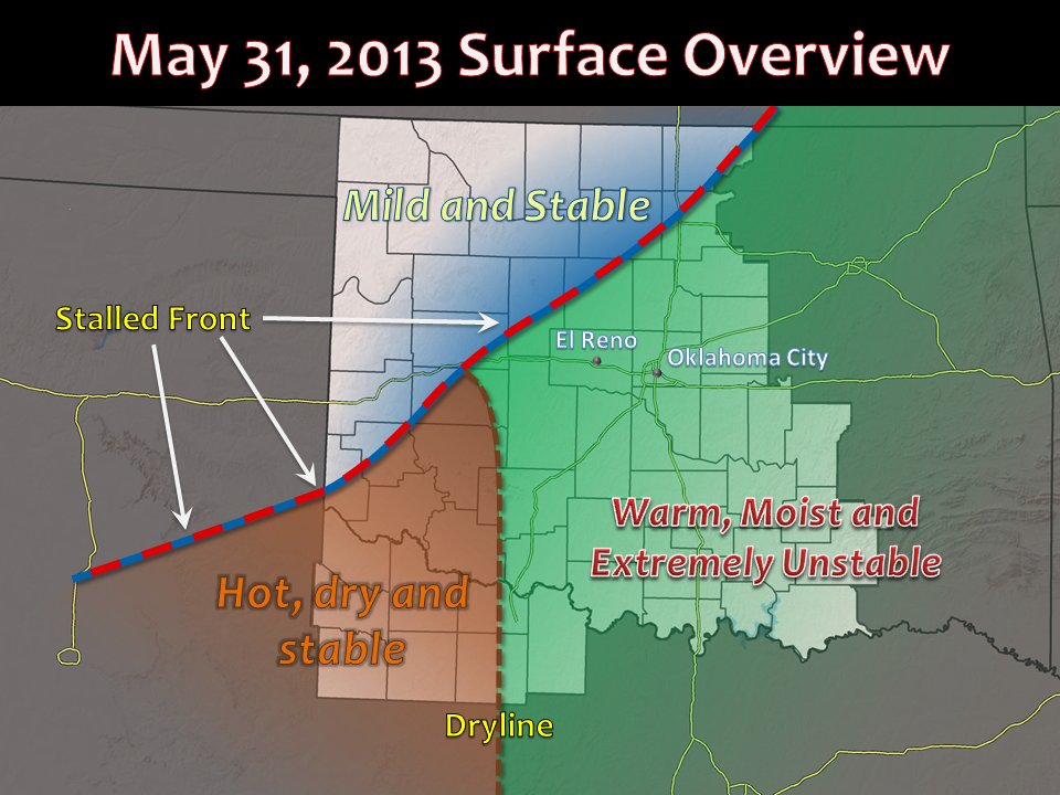
Surface diagram by the Norman, Oklahoma National Weather Service Office
The dryline-boundary intersection was initially south of Interstate 40, but its exact latitude at "storm time" would depend on how much this area lifted north through the afternoon. Accordingly, the plan was to drift southwest to I-40 and monitor the progress of the boundary throughout the afternoon. This was a very short distance from my hotel, so I had plenty of time to get some coffee and stop to pick up an additional external hard drive. I needed more space to offload and back up all of the video and photos from my cameras after such an active week of storm chasing on the Great Plains.
I slowly made my way south and west on the county roads through the morning and into the afternoon, stopping several times to keep an eye on satellite, surface observations and mesoanalysis. Eventually, the boundary intersection ended up roughly along I-40, and it appeared that El Reno was the place to stage to await storm development. Again, I didn't have far to go and had a couple of hours until storm time, so I stopped at the little OK Barber Shop on Banner Road to get a haircut. After this, I headed over to a gas station at the intersection of Highway 81 and Route 66 on the southeast side of El Reno. I ran into a lot of my chaser friends, an we hung out and chatted for a while.
Eventually, we saw that the cumulus field to our west was agitating and beginning to show signs of imminent storm development. Finally these updrafts broke through the cap and reached anvil level, and the western sky was beginning to darken. As these anvils spread overhead, it was time to leave and begin the active part of the chase.
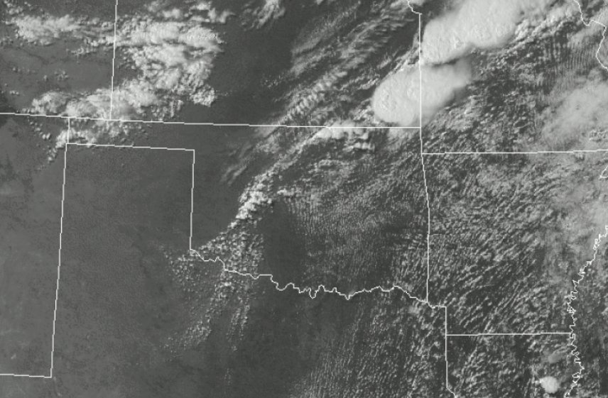
Visible satellite image showing initiation of thunderstorms west of El Reno.
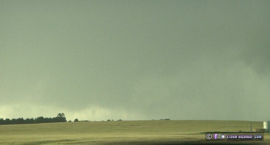
I initially headed north out of El Reno. There were three storms that had formed in a north-south line: one to my due west, another to the northwest and a third to the southwest. While the tail-end (southern) storm is usually favored for tornadoes, any of these three could become the storm of the day - so I positioned northwest of El Reno to await a dominant cell to emerge. Also, with storm motions expected to be northeasterly, I expected the southern cell - if it became dominant - might end up north of I-40 by the time it was organizing into a supercell.
Eventually, the southern storm began taking over as the dominant cell, and it had already started to turn right and head more easterly than northeasterly. So I made the call to intercept the southern storm right along and south of I-40 west of El Reno.
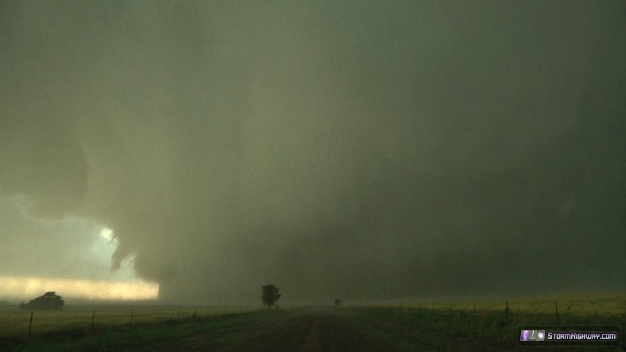
When I arrived on the storm, it was high-precipitation (HP) with any mesocyclone buried in the rain.
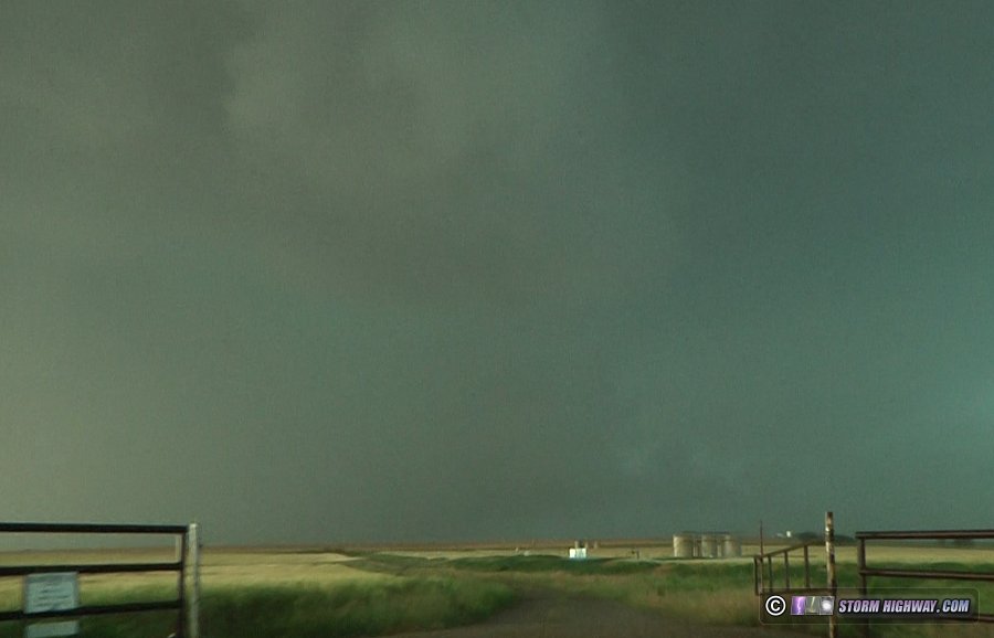
I moved east another couple of miles to S Heaston Road and stopped just north of Jensen Road to look back west again. A tornado was reported shortly after I arrived at this location. I could see rapid motion, a surging RFD and strong rotation in the rain curtains highly supportive of a tornado, but I saw no debris or condensation:
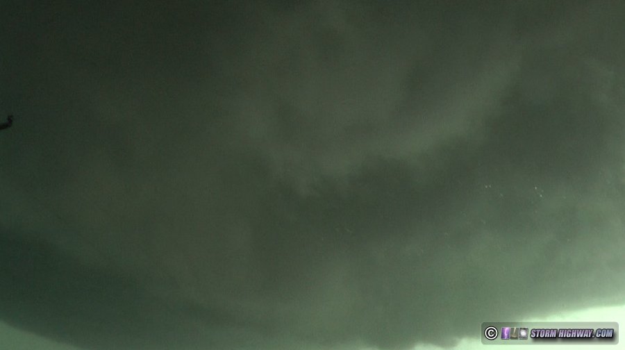
During this time, a new mesocyclone associated with the storm's next cycle was taking shape right overhead at my location at Jensen Road and S Heaston Road. A very low-to-the-ground forward-flank tail cloud was racing rapidly north-to-south into an area of strong rotation in the wall cloud nearly overhead of me:
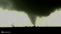
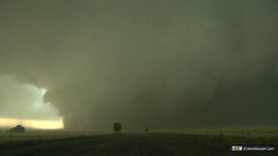
Moments after I turned east onto Jensen Road, the tornado rapidly developed just to my south.
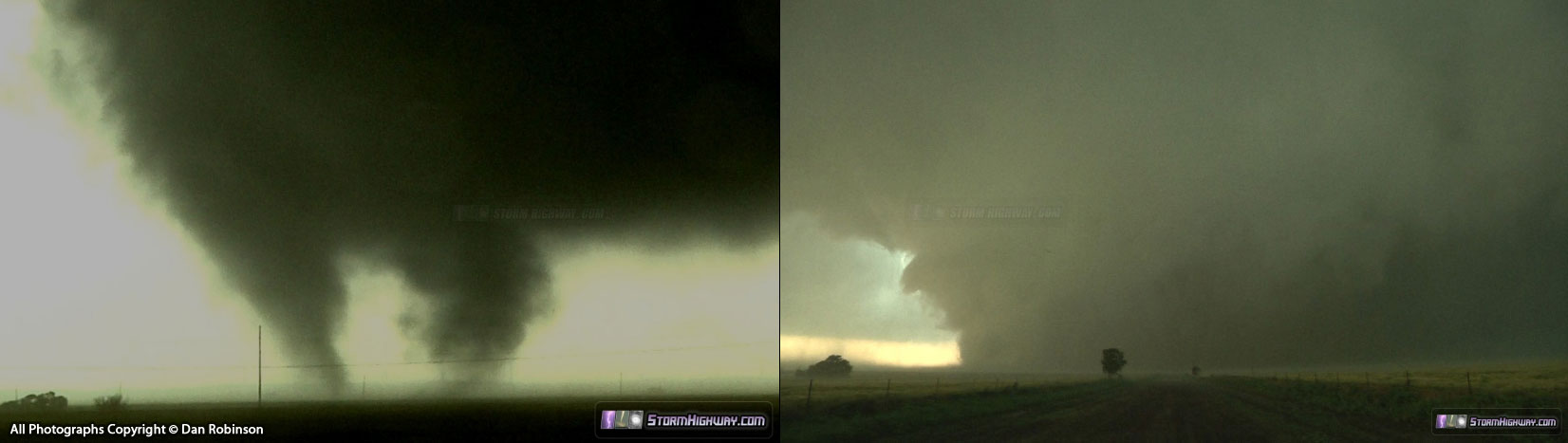
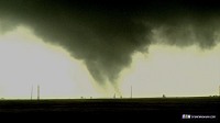
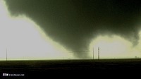
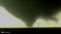
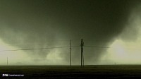
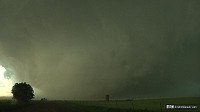
I observed and filmed the start of the El Reno tornado for several minutes on Jensen Road about 1/2 mile east of S Heaston Road. The tornado exhibited multiple vortices, horizontal vortices and extremely rapid motion (the fastest I have observed to date). The tornado was initially approximately one half mile to my due south (as the damage survey indicated - view my annotated GPS log).
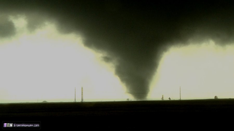
 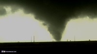            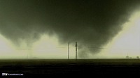    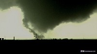
As heavy rain began falling at my location, I then proceeded east on Jensen Road. The tornado was still ongoing to my south, and was clearly moving farther away as I paralleled it heading eastbound on Jensen. From this I derived that the tornado was moving in an east-southeasterly direction.
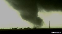
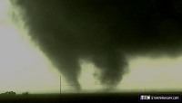
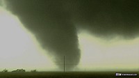
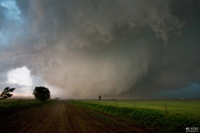
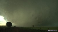
The tornado soon wrapped completely in rain, but moments later was faintly visible as a large wedge, still moving farther south away from Jensen Road. This appearance continued as I approached S Choctaw Avenue. Due to the tornado's apparent southward component of movement, I chose to turn south from Jensen onto S Choctaw for one mile to position closer to maintain a good visual.
I estimated at this point that it was two miles to the south. It was heavily rain wrapped at this time, but its outline was still easily visible. Here was my view looking south on S Choctaw at this time at 6:17:07 PM CDT:
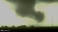
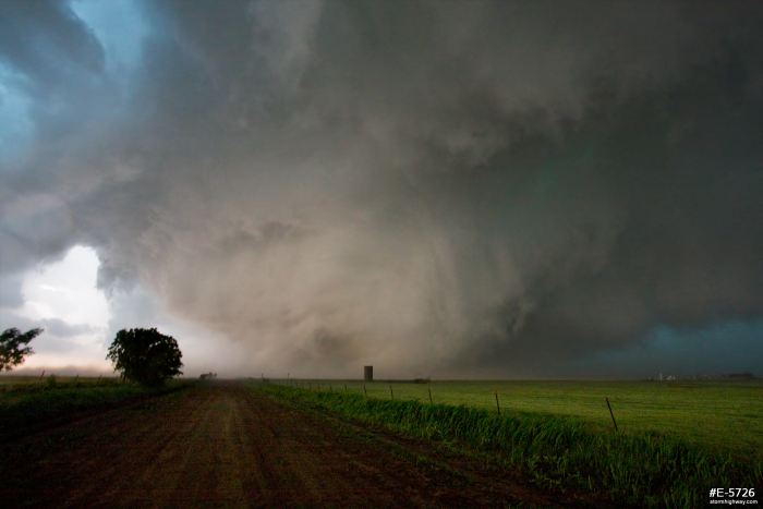
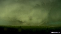
Power flashes were visible as I traveled south on S Choctaw at 6:17:44 PM CDT. I was also monitoring another wall cloud with rapid motion visible just to my north.
I chose to turn east on NW 10th Street (Reuter Road) at 6:17:59 PM CDT to position safely northeast of the tornado to obtain a better contrasted view. At this stage, it appeared the north edge of the tornado was approximately 1.5 miles to the south. At this time, the tornado gave no indication that it had deviated from its eastward movement.
At the intersection of NW 10th and Highway 81 at 6:19:21 PM CDT, I briefly considered turning south again on Highway 81, but could see that the tornado was already beginning to cross the highway to the south by approximately 1 mile. For this reason I chose to continue east on NW 10th to maintain a safe distance. At this point at 6:19:25 PM CDT, the white Chevy Cobalt occupied by the Twistex crew was immediately behind me.
Other than the Twistex Cobalt and a red pickup truck parked along Highway 81, there were no other vehicles in our immediate vicinity. In other words, chaser traffic was a non-factor at our location.
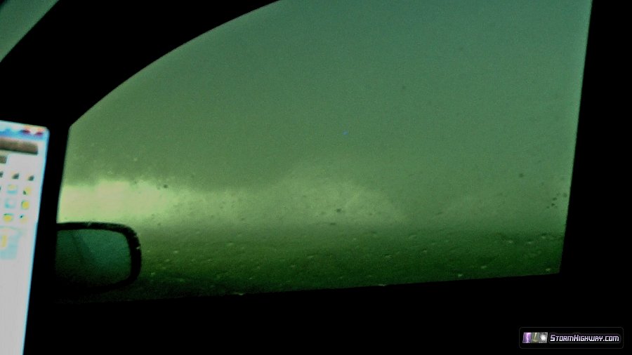
At this stage, my last visual assessment of the tornado was that it was continuing its general eastward movement while crossing Highway 81. However, after traveling approximately 1/2 mile on NW 10th/Reuter east of Highway 81, I observed the rain curtains rapidly approaching the road from the south at 6:20:01 PM CDT. This is visible on the front-facing dash camera. At the same time, the ill-defined wedge tornado suddenly appeared to the south rapidly approaching the road. At this time, the tornado is not yet visible on either front or rear cameras.
This was my first indication of trouble, and I began accelerating eastward to escape. The rain curtains and inflow winds into the tornado quickly enveloped the car at 6:20:23 PM CDT. My car's wheels were struggling to grip the gravel road against the force of the wind, and the vehicle's traction control was continuously engaging and reducing power to the wheels. The vehicle was struggling to maintain speed and was difficult to control. I made several unsuccessful attempts to disengage the traction control.
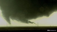
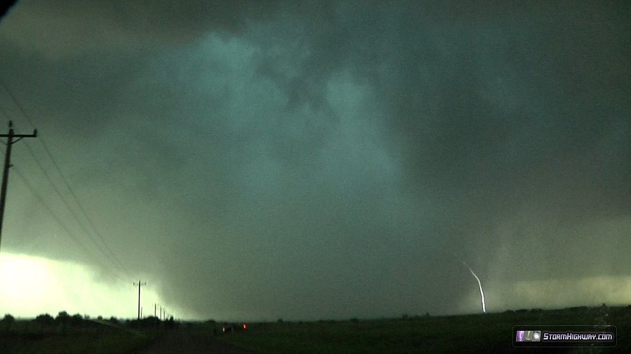
My rear-facing camera shows three satellite tornadoes or subvortices during this time. The first satellite is visible as a brief rope tornado just south of due west 6:20:17 PM CDT. Another brief rope satellite is visible due west at 6:20:33 PM CDT. The third satellite or subvortex emerges from the rain on the left side of the screen as a large barrel/cylinder tornado 6:21:48 PM CDT. At this stage, the main tornado is still off-camera to the left. Jeff Piotrowski's video at this time, shot from the north, shows this barrel tornado as the only fully condensed vortex (at around 3:40 in his video). The large barrel satellite/subvortex then merges or expands very rapidly into the main condensed wedge tornado at maximum width, which then is visible overtaking NW 10th/Reuter at 6:22:19 PM CDT. Nearly the entire rain curtain zone condenses into a wedge at this stage, this happens very rapidly.
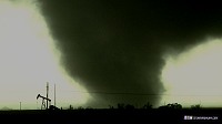
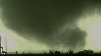
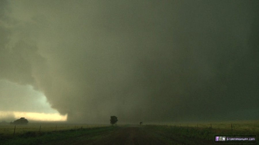
I finally abruptly emerged from the winds and rain curtains just east of the Evans Road intersection on 10th/Reuter, and could now see that I was out of the path of the tornado's core clearly behind me. I stopped briefly to observe the wedge tornado now crossing NW 10th/Reuter a few hundred yards to my west. Violent motion was apparent.
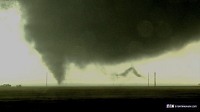
This was my view (video captures) looking due west 6:23:50 PM CDT down NW 10th/Reuter Road at what I had just barely escaped from. The east edge of the tornado is right at Evans Road:
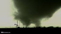
After 40 seconds, I repositioned east again to maintain a safe distance from the tornado. Now out the path of its core, I then exited the vehicle to obtain video and photographs. I was not aware that the tornado's actual outer circulation was still over me, as I would discover later. These are the two DSLR still images I obtained at this time, both at 10mm on the Canon 10-22mm wide-angle lens (click each to open a full screen view):
This still image was taken at 6:25:37 PM CDT:
This still image was taken at 6:25:43 PM CDT:
Video captures:
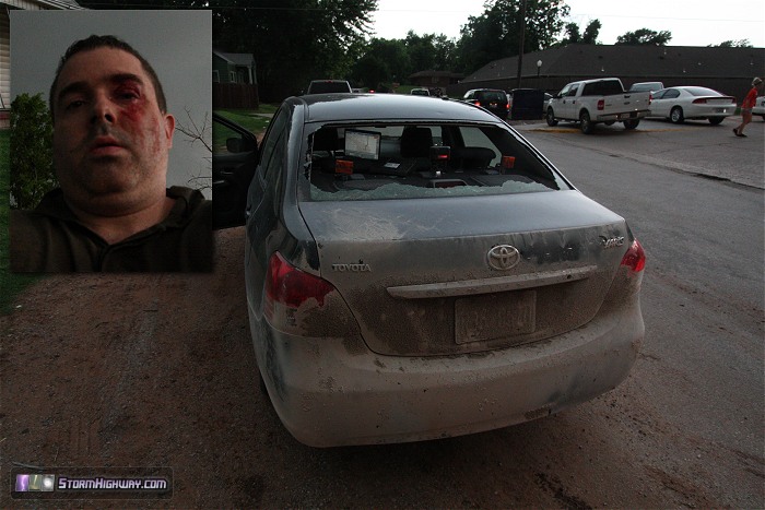
After a few seconds, the winds associated with the outer circulation of the tornado - in excess of 100mph - struck me and the car. This was confirmed by University of Oklahoma RaXpol mobile radar data to be tornadic winds, not RFD or an inflow jet as I initially believed. The force of the wind caused me to stumble across the road and into a fence. One of my loose-fitting shoes was blown off and into the field. One to two inch hailstones, driven sideways by the wind, began impacting me and the car. The first impact to me was directly into my left eye, opening a 1.5" gash above my eye. Several other wind-driven hailstones and debris objects impacted me in the seconds following. I ran and dove into the ditch on the south side of the road to escape the hail and any other wind-driven debris. I remained lying flat and covered my head with my hands for about 45 seconds until the hail and wind subsided.
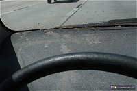
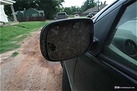
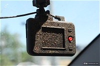
During this time, my car also suffered damage to the rear window and both external mirrors. My laptop screen in the front of the car also suffered a hailstone strike and was cracked. Most of the glass from the rear window blew into the front half of the car, with glass piling up at the bottom of the windshield.
At this time, I chose not to continue the chase due to my injuries and vehicle damage. My eye was bleeding, face half covered in blood and dirt, and arms and back with bruises and scratches. I tried to drive south away from the storms (noticing another tornado off to the northeast that turned out to be anticyclonic), but had considerable difficulty due to heavy traffic from fleeing local residents. I eventually made it safely out of the path of the storm complex to Chickasha, Oklahoma to assess my injuries and the extent of the damage.
It was not my intent to get into the path of this tornado. I expected its eastward movement to continue with a gradual curve toward the north when it weakened. One moment it was due south of me by at least a mile, the next it was right on me.
Additional resources
Dan Robinson's El Reno Tornado FAQ (Please read!): El Reno tornado incident questions & answers
|