|
Storm Chasing Home | Tornado Intercepts | Storm Chasing FAQ | Expeditions by Year | Video Clips | Photo Gallery
Great Plains chase log: May 23-24, 2003
: Trip #3 to Tornado Alley in 2003
Highlights of this chase:
- Lightning in Southwest Oklahoma on 5/24
- Possible wall cloud near Altus, OK on 5/24
- First Allsup's Burrito experience
RealVideo Clip (3.6 MB): May 24 Event Video
Click on selected thumbnail images to enlarge
With another 3,000 storm chasing miles logged this weekend, my truck is fast approaching Meatwagon status. I knew the chances for tornadoes/photogenic supercells were somewhat slim when I left for Kansas on Friday. However, there were a few out there - which I didn't witness except after dark. My goal was to at least bag some lightning over the 3-day weekend.
5-23-03
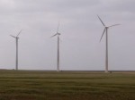 Friday was a travel day, finishing up the long drive from WV. After staying in High Hill, MO for the night, I set out for southwestern Kansas at 7:00AM, arriving in the tiny town of Elkhart, KS around 6:00PM central time. On the way, stopped to get some shots of the big wind farm near Montezuma (made a note: these would make a great lightning photo subjects). Friday was a travel day, finishing up the long drive from WV. After staying in High Hill, MO for the night, I set out for southwestern Kansas at 7:00AM, arriving in the tiny town of Elkhart, KS around 6:00PM central time. On the way, stopped to get some shots of the big wind farm near Montezuma (made a note: these would make a great lightning photo subjects).
The best storms of the day were down in New Mexico and the extreme western Oklahoma panhandle. There was no way to make these before dark (though I gave it a shot, going as far as Stratford, TX). After filming a couple of Union Pacific "grain trains on the Plains" at sunset, I stopped at Guymon, OK for the night, anticipating another chance on Saturday in the panhandle area.
5-24-03
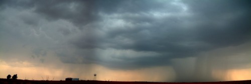
In the morning, I headed south to Childress and waited. Storms began to fire in the area around 5:00PM, with one just west of downtown Childress (digital photo):
(timelapse in video above)
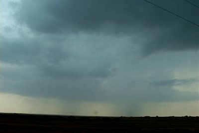
Despite the striking rain shaft and a small area of mammatus, this cell never looked very organized. As I drove east on 287 to stay ahead of it, it quickly died out, with two new cells going up just to its northeast. The second storm began firing out huge CG bolts, and I quickly repositioned and aimed the camera at it - but it refused to produce another bolt after I had it framed (capture from video):
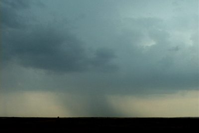
Saw a couple groups of storm chasers here also. Meanwhile, a third cell had gone up just ahead of storm #2 and also started throwing out intense CGs. I again stopped to shoot this new cell, but it too, decided to die after I had the camera on it (capture from video):
Man, I just couldn't get a break! Unfortunately this trend would continue later in the evening. After getting a hotel room at Altus, OK, I headed back west to the Texas state line along Rt. 62 to wait on the MCS now moving southeast toward the Red River. Distant CGs were visible at this point, colored orange from dust particles in the air:
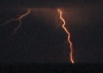 
(view in video above)
After this continued for a while, I decided to drive west to get closer to this activity, but again, it died out as I approached it.
Heading back east toward Altus, I saw a huge cell NE of the town that had gone severe, with constant lightning. The cell was moving slowly southwest directly at me, so I set up just west of Altus on Rt. 62 to wait on it. As it approached, it began to collapse - and the outflow winds were tremendous. Possibly 50 MPH or more, knocking over both of my tripods w/cameras on them. Twice. The second time, I had spread the heavy video tripod legs out so that the camera was only a couple feet off the ground. "That should be safe." Nope! As soon as I walked away from it again, there it went. Good thing the camera impact zones were soft dirt. Despite that fact, my TRV900's LCD screen hinge is now slightly bent from the two impacts. Ouch. Thankfully everything still works.
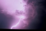
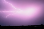
As the Altus cell approached, an ominous structure was clearly visible as it was illuminated by lightning (images from 35mm slides):
 
With the strong outflow winds coming *out* of this storm, I didn't think it was possible that this was anything to get excited about. But, soon after this, a tornado warning was issued for the Altus area (Jackson County) as a result of strong doppler-indicated rotation. Was this a wall cloud? I'm not sure. It looked very dramatic as it passed just to my east. I recorded this on 35mm film with lightning-aided illumination as well as on video.
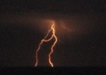
As I drove back toward Altus, quarter-sized hail was falling, along with very bright, sonic-booming CGs jumping around here and there (left - 35mm slide, right - video capture):
(view video of these strikes)
As the Altus cell died out, a new line of intense convection exploded over the Red River to my south. The lightning at first looked weak, and it was moving away to the south, so I went back to the hotel to crash for the night. (Big mistake).
I flipped on the TV an hour later to see that the line was still going strong, and remaining stationary over the Red River only 25 miles to my south! Oops! I immediately got back on the road and headed south toward the Texas border. The southern sky was an ocean of lightning, and I was swimming in it. Absolutely awesome sight. But it was time for me to strike out again (no pun intended).
I stopped several times to try and film the spectacular show, unrivaled by any I'd seen except for maybe May 29, 2001 in OKC. But, the driving rain and wind would not give me a break! I had no choice but to keep going, hoping for a break in the rain. The lightning was frequent, unrelenting and beautiful. The rain and wind finally abated as I approached the Red River, with close, vivid CGs everywhere. Perfect!!! I searched for a pull-off spot, found it, and set up the cameras inside my truck, pointed out the driver's side window (too dangerous to stand outside).
The CGs stopped.
You've got to be kidding me.
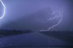
A few distant anvil crawler/CG combos went off in frame of the cameras (photos from 35mm slides):
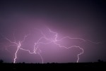 
Intermittent intracloud/anvil crawlers continued sporadically for the next hour, but *nothing* like what was happening just moments earlier. If I had stayed out initially, I could have filled three rolls of slide film and two videotapes with trophy lightning shots.
I'm thankful for what I did get, however. I could have come home completely empty-handed like the last two trips.
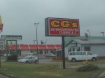
On the drive home yesterday, I tried to forget about missing all of that lightning, but I kept being reminded of it. Like by this restaurant sign in Lawton, OK:
One more thing. While in Texas on Saturday, I was priveleged to partake of the legendary storm chaser culinary icon:
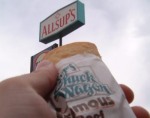
Not too bad, despite all the hype otherwise. OK, now my photography experience is complete. Well, except for that whole seeing a tornado thing.
Until next time.......
Storm Chasing Home | Tornado Intercepts | Storm Chasing FAQ | Expeditions by Year | Video Clips | Photo Gallery
GO: Home | Storm Chase Logs | Photography | Extreme Weather Library | Stock Footage | Blog
Featured Weather Library Article:
|


