 St. Louis area supercell: May 3, 2010 St. Louis area supercell: May 3, 2010
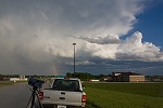
ABOVE: Supercell near New Douglas, IL on May 3, 2010.
Click any thumbnail on this page to view a larger version.
HD EXPEDITION VIDEO: St. Louis area supercell and funnel: Watch Video
NEW DOUGLAS, IL - This type of day was one of the reasons I chose to live in the St. Louis area! Monday, May 3 was a 'cold core' type day in the lower Midwest. We were out of the deep moist warm sector - with the 500mb trough axis passing overhead, bringing cold midlevel temperatures. We still had some good upper support however, and clear skies allowed for a decent amount surface heating and resultant CAPE/good lapse rates, despite the relatively meager surface dewpoints. Therefore, severe storms - mainly in the form of high-based hailers - were in the cards for the St. Louis metro area. The wind profiles also allowed the chance of supercells. Models seemed to have a good handle on the events of the day.
I started the day at my apartment in New Baden, again a very convenient initial target for the day. A north-south outflow boundary was located just to the east of downtown St. Louis, was nearly stationary, and was plainly visible on radar. This boundary was of particular interest to me should any storms manage to interact with it. By mid-afternoon, a line of storms initiated right on this boundary and began moving eastward. I sat on County Line Road, about 1/4 mile from home, watching these cells approach:
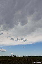
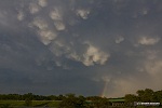
Mammatus appeared to the east:
A cell to the south near Mascoutah was the dominant player, and it soon began to split - sending the left split rapidly northeast through New Baden, while the right mover turned east-southeast toward Venedy.
The right mover actually developed a nice hook on radar for a few scans (which I saw after getting home, not visible on WxWorx), though I could see the base was very high and in little danger of going tornadic. I got in front of the right-moving cell south of Venedy:
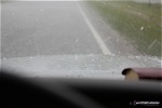
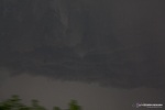
The storm had a nice base and dense rain shaft, but no areas of rotation or lowerings. I moved north about a mile to get into the radar-indicated hail maximum in the core, expecting 1-inch stones max. Dimes were the largest I saw.
At this point, I decided to let these storms go, since they didn't show much sign of doing anything worth following them for very long. I returned to my apartment in New Baden to get more detailed data. A strong east-moving cell north of I-70 in Missouri got my attention, heading for the northern St. Louis suburbs in the Alton area. I thought that the storm might do something interesting once it reached the outflow boundary still hanging out east of St. Louis. I got back on the road and headed toward the Alton area to watch the storm approach. I took Route 4 north to Route 140 at Hamel, then turned west toward the storm. WxWorx was showing the storm moving east at more than 45-50mph, so I didn't want to get too close and not be able to make it back east for the boundary interaction.
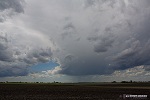
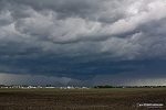
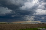
West of Hamel, I got my first visual of the storm's base:
Radar had shown the storm with a persistent circulation and a slight right-turn south of due east, so I thought that if it continued moving right, it could go right through Alton. For this reason, I stopped in Bethalto and headed back to the east side of town to see what the storm would do. Traffic was heavy in Bethalto, and I didn't think I would be able to reposition well if I stayed in the town. After a few radar scans and visual observations, it became apparent that the storm was no longer moving right, but resuming its eastern course. It looked now to be actually lifting east-northeast, and would pass well to the north of Bethalto. I took a few shots of the storm from the east side of Bethalto before heading back east:
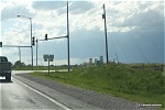
This was the view to my northeast, just west of Hamel. The dense cumulus clouds on the right-hand side of the photo mark the location of the outflow boundary:
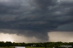
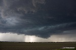
I got on I-55 northbound at Hamel to get in front of the storm so I could better chase the boundary interaction event. The storm structure was getting quite impressive and dramatic as I exited at Livingston:
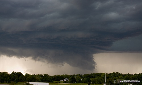
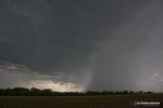
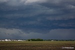
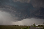
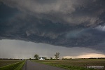
I headed east to New Douglas to get a clear, open view of the approaching storm. The outflow boundary was directly overhead, so I stopped and waited for the show to begin. The storm structure was breathtaking as it approached:
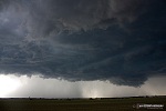 
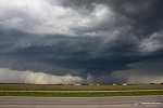
In the next few minutes, the storm began interacting with the boundary, as expected. A new updraft quickly went up on the boundary just ahead of the main storm, with broad rotation and rising motion evident:
 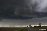 
The main storm's precip was catching up to me, so I was forced to move east. As I did, a funnel quickly appeared in the base just to my north:
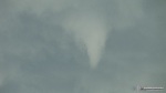 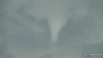 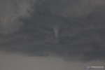 
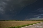
The funnel spun for about 2 minutes before disappearing. At this point, a storm chaser's nightmare appeared ahead of me - a sign stating that the road to the east was closed! I would have to take a rural road south to Highway 140 and resume the chase east from there. The long drive south to 140 cost me my position ahead of the fast-moving storm, and I was never able to catch up again. This was the view to the east as I headed south near Old Ripley, as the storm pulled well ahead of me.
Once I reached 140, I was about a mile or so behind the storm.
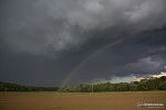
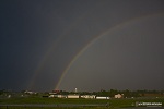
I tried in vain to catch up, going as far as Vandalia on I-70 before finally giving up. On the way, a vivid rainbow appeared, followed by mammatus and a nice display of convection on the rear flank of the storm to the south.
I decided it was inconsequential that I lost the storm due to the closed road, as it weakened considerably after crossing the boundary. I arrived at home before dark - something I'm not used to after such a quality chase like this. I'm definitely looking forward to many more great backyard storm days as a result of living here. The lower Midwest is truly an underrated chasing area, and I'm glad to have discovered it.
May 3, 2010 LINKS:
- Edwardsville, IL chaser John Farley was also on this storm, in fact likely only a mile or two from me at times. His chase account, along with a nice radar loop showing the storm and the boundary, can be found here: May 3, 2010 Southwest Illinois Chase
- Charles Edwards and Cloud 9 Tours were on this storm earlier in Missouri as it dropped copious large hail - their video is located here: May 3rd, 2010 Golfball size hail
NEXT EVENT: Miami, OK lightning >
GO: Home | Storm Chase Logs | Photography | Extreme Weather Library | Stock Footage | Blog
Featured Weather Library Article:
|


