2003 Weather Story Archive
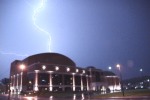
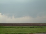
 A Week for Weather Headlines: Tornadoes, hail, strong winds, and heavy rain accompanied many of the storms that affected the Ohio/West Virginia region on November 12. By late night, the storms were on their way out, but the event was far from over. River flooding and lingering high winds made November 13 another challenging day for the area. The Elk, Kanawha, Coal, Gauley, Guyandotte and other rivers ran very high, and some crested at or above flood stage. Right: The DOW (Doppler On Wheels) truck visits Akron, Ohio on November 12 A Week for Weather Headlines: Tornadoes, hail, strong winds, and heavy rain accompanied many of the storms that affected the Ohio/West Virginia region on November 12. By late night, the storms were on their way out, but the event was far from over. River flooding and lingering high winds made November 13 another challenging day for the area. The Elk, Kanawha, Coal, Gauley, Guyandotte and other rivers ran very high, and some crested at or above flood stage. Right: The DOW (Doppler On Wheels) truck visits Akron, Ohio on November 12
[ Full Story ]
 Lunar Eclipse: The eastern USA enjoyed a total lunar eclipse on November 8. The eclipse started after 6:00PM and lasted until after 10:00PM. The moon turned a deep orange-red color during totality at 8:06PM EST (right). Skies over most of West Virginia were clear, allowing for an easy view of the event. Lunar Eclipse: The eastern USA enjoyed a total lunar eclipse on November 8. The eclipse started after 6:00PM and lasted until after 10:00PM. The moon turned a deep orange-red color during totality at 8:06PM EST (right). Skies over most of West Virginia were clear, allowing for an easy view of the event.
[ Full Story & Photos ]
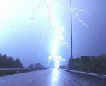
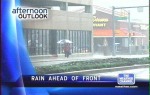 On TV: An approaching cold front brought heavy rain to West Virginia throughout most of the day on November 5, making for a drenching commute. Temperatures will slowly begin to fall as the frontal boundary passes and allows cooler air to push into the region. Right: Heavy rain in Charleston, from Storm Highway video broadcast nationally on The Weather Channel on November 5. On TV: An approaching cold front brought heavy rain to West Virginia throughout most of the day on November 5, making for a drenching commute. Temperatures will slowly begin to fall as the frontal boundary passes and allows cooler air to push into the region. Right: Heavy rain in Charleston, from Storm Highway video broadcast nationally on The Weather Channel on November 5.
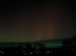 Northern Lights - The state enjoyed a rare display of Aurora Borealis Thursday night just after sunset. Green, red and white colors glowed in the northern sky between 7:00PM and 8:00PM. Faint columns of white continued to appear in the sky until midnight. Northern Lights - The state enjoyed a rare display of Aurora Borealis Thursday night just after sunset. Green, red and white colors glowed in the northern sky between 7:00PM and 8:00PM. Faint columns of white continued to appear in the sky until midnight.
[ Full Story & Photos ]
LINK: spaceweather.com - Info on solar flares and auroras
2001 PHOTO ARCHIVES: Auroras in West Virginia on November 6, 2001
 On TV: Rush-Hour Drama - During a Storm Highway video shoot October 27 on Fort Hill in downtown Charleston, the camera caught part of a hair-raising series of back-to-back collisions on Interstate 64. Rain-slickened roads contibuted to the chain reaction accident involving at least 12 vehicles on the Interstate 64 bridge over the Kanawha River. Right: Scene from Storm Highway video broadcast nationally on The Weather Channel on October 27. On TV: Rush-Hour Drama - During a Storm Highway video shoot October 27 on Fort Hill in downtown Charleston, the camera caught part of a hair-raising series of back-to-back collisions on Interstate 64. Rain-slickened roads contibuted to the chain reaction accident involving at least 12 vehicles on the Interstate 64 bridge over the Kanawha River. Right: Scene from Storm Highway video broadcast nationally on The Weather Channel on October 27.
[ Full Story ]
NEWS VIDEO: Accident caught on video: Storm Highway Video Clip
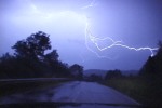
 WINDY EVENING: Although most of West Virginia escaped severe weather from the cold frontal passage on October 14, strong winds behind the front kept the air stirred up around the Mountain State. WINDY EVENING: Although most of West Virginia escaped severe weather from the cold frontal passage on October 14, strong winds behind the front kept the air stirred up around the Mountain State.
[ Full Story ]
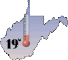 19 Degrees F: The coldest temperature in the state on the morning of October 3 in Canaan Valley, Tucker County. The rest of the state experienced freezing temperatures with widespread frost. A few low temperature records were either broken or closely approached. 19 Degrees F: The coldest temperature in the state on the morning of October 3 in Canaan Valley, Tucker County. The rest of the state experienced freezing temperatures with widespread frost. A few low temperature records were either broken or closely approached.
LINK: National Weather Service - Public statement on October 3 morning's temperatures
 Small thunderstorms developed and moved over parts of the Mountain State on September 28, in spite of the cool autumn air that had settled into the region. Small thunderstorms developed and moved over parts of the Mountain State on September 28, in spite of the cool autumn air that had settled into the region.
[ Full Story ]
 The 2003 storm season is drawing to a close in West Virginia, but that doesn't mean that the skies aren't worth watching. A pair of bright sun dogs showed up in the western sky on September 6 as Dunbar prepared for the big crusade at Shawnee Park. The 2003 storm season is drawing to a close in West Virginia, but that doesn't mean that the skies aren't worth watching. A pair of bright sun dogs showed up in the western sky on September 6 as Dunbar prepared for the big crusade at Shawnee Park.
[ Full Story ]
LINK: Dunbar's Crusade for Christ: News and Photos
 Several thunderstorms passed over downtown Charleston on August 28, bringing heavy rain, frequent lightning, and minor flooding - but ending with a nice full rainbow over the city. Several thunderstorms passed over downtown Charleston on August 28, bringing heavy rain, frequent lightning, and minor flooding - but ending with a nice full rainbow over the city.
[ Full Story ]
 A lone but strong thunderstorm rolled across the Kanawha Valley on August 27. Heavy rain and frequent lightning were the main features of this system. A lone but strong thunderstorm rolled across the Kanawha Valley on August 27. Heavy rain and frequent lightning were the main features of this system.
[ Full Story ]
 Severe thunderstorms plowed across central Ohio and northern West Virginia on August 26 before moving on towards the Altantic coast. High winds in excess of 65mph caused tree and power line damage, and frequent, powerful lightning was the norm. Severe thunderstorms plowed across central Ohio and northern West Virginia on August 26 before moving on towards the Altantic coast. High winds in excess of 65mph caused tree and power line damage, and frequent, powerful lightning was the norm.
[ Full Story ]
EXPEDITION VIDEO: Severe thunderstorms in Ohio: Storm Highway Video Clip
 Scattered thunderstorms from New York to North Carolina lit up most of the eastern USA on August 16. Steelers fans at Heinz Field in Pittsburgh were treated to a show of lightning during the exhibition game against Philadelphia. Scattered thunderstorms from New York to North Carolina lit up most of the eastern USA on August 16. Steelers fans at Heinz Field in Pittsburgh were treated to a show of lightning during the exhibition game against Philadelphia.
[ Full Story ]
EXPEDITION VIDEO: Pittsburgh lightning: Storm Highway Video Clip
 Stationary storms hovered over southern Kanawha County for over an hour and a half on August 9, with a fairly steady display of cloud-to-ground lightning strikes. The areas most affected were south of Charleston along Corridor G, particularly Ruthdale and the Southridge Centre / Trace Fork shopping complexes. Stationary storms hovered over southern Kanawha County for over an hour and a half on August 9, with a fairly steady display of cloud-to-ground lightning strikes. The areas most affected were south of Charleston along Corridor G, particularly Ruthdale and the Southridge Centre / Trace Fork shopping complexes.
[ Full Story ]
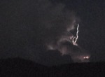
 Ominous-looking storms charged through most of the state on August 4. Severe weather was reported in a few isolated locations. Ominous-looking storms charged through most of the state on August 4. Severe weather was reported in a few isolated locations.
[ Full Story ]
EXPEDITION VIDEO: Storms in the Kanawha Valley on August 4: Storm Highway Video Clip
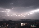
 Numerous thunderstorms hovered over West Virginia from the evening of July 18 into the morning of the 19th, giving most areas an unrelenting dose of all-night lightning. Severe weather was noted in northern parts of the state. Numerous thunderstorms hovered over West Virginia from the evening of July 18 into the morning of the 19th, giving most areas an unrelenting dose of all-night lightning. Severe weather was noted in northern parts of the state.
[ Full Story ]
EXPEDITION VIDEO: Lightning over the New River Gorge: Storm Highway Video Clip
 Late night storms rolled into the state before midnight on July 15, bringing a great light show to parts of the state. The storms continued to flash long into the early morning hours. Late night storms rolled into the state before midnight on July 15, bringing a great light show to parts of the state. The storms continued to flash long into the early morning hours.
[ Full Story ]
DIGITAL VIDEO: 'Anvil Crawlers' over WV and OH: Storm Highway Video Clip
VIDEO FRAMES: Sky-filling lightning in Teays Valley, WV: GIF Movie, 1.3MB
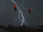
 Evening thunderstorms come and go over Charleston on July 12, leaving an array of camera-worthy sights over town in the form of rainbows, lightning and various colorful cloud formations. Most of the state was under two severe thunderstorm watches which spanned most of the day. Evening thunderstorms come and go over Charleston on July 12, leaving an array of camera-worthy sights over town in the form of rainbows, lightning and various colorful cloud formations. Most of the state was under two severe thunderstorm watches which spanned most of the day.
[ Full Story ]
 Significant severe weather affected many counties in western West Virginia on July 10, with an F2 tornado reported near Parkersburg and up to 100mph winds affecting parts of Jackson County. Significant severe weather affected many counties in western West Virginia on July 10, with an F2 tornado reported near Parkersburg and up to 100mph winds affecting parts of Jackson County.
[ Full Story ]
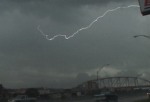
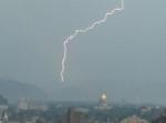
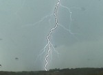
 Frequent and dazzling lightning accompanied thunderstorms that charged through the Charleston-Huntington metro areas on July 9. The WCHS TV tower in Teays Valley received numerous direct strikes during the storms. Frequent and dazzling lightning accompanied thunderstorms that charged through the Charleston-Huntington metro areas on July 9. The WCHS TV tower in Teays Valley received numerous direct strikes during the storms.
[ Full Story ]
EXPEDITION VIDEO: Intense lightning in Teays Valley: Storm Highway Video Clip
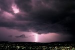
 Incredible storms put on a show for the Charleston area on July 7, even though they didn't pass directly over the Kanawha Valley. Enormous thunderstorms loomed in the northern sky over Charleston at sunset, putting on a breathtaking display of lightning and sunlit clouds. Incredible storms put on a show for the Charleston area on July 7, even though they didn't pass directly over the Kanawha Valley. Enormous thunderstorms loomed in the northern sky over Charleston at sunset, putting on a breathtaking display of lightning and sunlit clouds.
[ Full Story ]
 Natural fireworks closed out the July 4th weekend in Charleston as a cluster of thunderstorms moved through the Kanawha Valley. Natural fireworks closed out the July 4th weekend in Charleston as a cluster of thunderstorms moved through the Kanawha Valley.
[ Full Story ]
 A night of rough weather lingered over eastern Ohio on July 5, with most of the activity staying to the west of the West Virginia state line. A night of rough weather lingered over eastern Ohio on July 5, with most of the activity staying to the west of the West Virginia state line.
[ Full Story ]
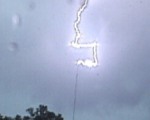
 Unexpected thunderstorms beat the odds and developed over West Virginia on June 28, even though no activity was forecast. One storm became severe, dropping one-inch hail on the coalfields and giving viewers in surrounding counties an interesting lightning display at a distance. Unexpected thunderstorms beat the odds and developed over West Virginia on June 28, even though no activity was forecast. One storm became severe, dropping one-inch hail on the coalfields and giving viewers in surrounding counties an interesting lightning display at a distance.
[ Full Story ]
VIDEO FRAMES: Cloud-to-air lightning: GIF Movie, 1.3MB
 Major flash flooding struck Kanawha County on June 16 for the second time in less than a week, but this time with much more severity. Significant damage to structures, vehicles and roads occurred as several streams north of town raged out of their banks, particularly from north Greenbrier Street to the Elkview/Pinch areas. Major flash flooding struck Kanawha County on June 16 for the second time in less than a week, but this time with much more severity. Significant damage to structures, vehicles and roads occurred as several streams north of town raged out of their banks, particularly from north Greenbrier Street to the Elkview/Pinch areas.
[ Full Story ]
NEWS VIDEO: June 16 floods: Storm Highway Video Clip
PHOTO GALLERY: Landslides, debris, damaged vehicles: View Photos
 Heavy afternoon thunderstorms pounded most of West Virginia on June 11, dropping up to 2 to 3 inches of rain in parts of Kanawha County. The heavy rains triggered widespread street flooding and landslides, bringing traffic in Charleston to a crawl. Heavy afternoon thunderstorms pounded most of West Virginia on June 11, dropping up to 2 to 3 inches of rain in parts of Kanawha County. The heavy rains triggered widespread street flooding and landslides, bringing traffic in Charleston to a crawl.
[ Full Story ]
NEWS VIDEO: Flooding in and around Charleston: Storm Highway Video Clip
 The severe weather tables turned east on May 31, as a strong low pressure system threatened the east coast with an unusual tornado outbreak. A trip to North Carolina and Virginia for the event saw very fast-moving storms, one of which produced a tornado less than an hour before we caught it. The severe weather tables turned east on May 31, as a strong low pressure system threatened the east coast with an unusual tornado outbreak. A trip to North Carolina and Virginia for the event saw very fast-moving storms, one of which produced a tornado less than an hour before we caught it.
[ Full Story ]
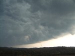 A strong but weakening line of storms dropped south across central West Virginia on May 29, treating motorists on I-79 to a breathtaking shelf cloud display in Roane County. A severe thunderstorm warning was issued for the Charleston area as the cells continued south. A strong but weakening line of storms dropped south across central West Virginia on May 29, treating motorists on I-79 to a breathtaking shelf cloud display in Roane County. A severe thunderstorm warning was issued for the Charleston area as the cells continued south.
[ Full Story ]
EXPEDITION VIDEO: Storm near Amma, WV on I-79: Storm Highway Video Clip
 Central Plains Trip #3 results in encounters with lightning, hail, and strong winds - but little else, as a persistent inactive pattern has a stronghold on Tornado Alley. After the record outbreaks in early May, the Plains have become unusually tornado-quiet for the remainder of the peak season. Central Plains Trip #3 results in encounters with lightning, hail, and strong winds - but little else, as a persistent inactive pattern has a stronghold on Tornado Alley. After the record outbreaks in early May, the Plains have become unusually tornado-quiet for the remainder of the peak season.
[ Full Story ]
 OUTBREAK WEEK - May 4-10: A second unplanned chase to Kansas, Oklahoma, Missouri and Illinois during five days of the most tornado-active week in US history yields little results. Despite the widespread severe weather, critical positioning decisions result in missing several large but fast-moving tornadoes in northeastern Oklahoma, southeastern Kansas, and northeastern Missouri. OUTBREAK WEEK - May 4-10: A second unplanned chase to Kansas, Oklahoma, Missouri and Illinois during five days of the most tornado-active week in US history yields little results. Despite the widespread severe weather, critical positioning decisions result in missing several large but fast-moving tornadoes in northeastern Oklahoma, southeastern Kansas, and northeastern Missouri.
[ Full Story ]
 An chase to Kentucky on May 5 yielded no tornadoes, but plenty of lightning and spectacular clouds. The system responsible for the major tornado outbreak in Missouri moved into the area, bringing a risk for more severe weather in Appalachia. An chase to Kentucky on May 5 yielded no tornadoes, but plenty of lightning and spectacular clouds. The system responsible for the major tornado outbreak in Missouri moved into the area, bringing a risk for more severe weather in Appalachia.
[ Full Story ]
DIGITAL VIDEO: Storms in Kentucky on May 5: Storm Highway Video Clip
VIDEO FRAMES: Lightning in Kentucky: GIF Movie, 1.3MB
 For the third day in a row, thunderstorms rolled through the state in the afternoon and evening hours on May 2. This day's lightning show was less intense than in previous days, but still a worthwhile sight. For the third day in a row, thunderstorms rolled through the state in the afternoon and evening hours on May 2. This day's lightning show was less intense than in previous days, but still a worthwhile sight.
[ Full Story ]
 West Virginia's stormy week continued on May 1 as numerous thunderstorms dotted the landscape. Another round of strong storms was expected to arrive from the west later in the evening. West Virginia's stormy week continued on May 1 as numerous thunderstorms dotted the landscape. Another round of strong storms was expected to arrive from the west later in the evening.
[ Full Story ]
DIGITAL VIDEO: Storms in Kanawha and Roane Counties on May 1: Storm Highway Video Clip
 Afternoon storms were widespread across the Mountain State on April 30. While frequent lightning and hail was common, only a few isolated severe weather incidents were reported. Afternoon storms were widespread across the Mountain State on April 30. While frequent lightning and hail was common, only a few isolated severe weather incidents were reported.
[ Full Story ]
DIGITAL VIDEO: Hail rains down near Red House in Putnam County on April 30: Storm Highway Video Clip
Broadcast-quality digital video (720x480 NTSC) from these storms is available. Please visit our Storm Highway section for more information.
More Headlines:
April 19: Central Plains Trip #1
April 16: Forest Fires
April 4: Route 35 Thunderstorms
March 20: WV & OH Thunderstorms
March 13: Thunderstorms & Valley Fog
February 23: River Flooding
February 22: Winter Thunderstorms
February 20: Ice Falls from Television Tower
February 19: WVAH Tower Collapse
February 16: Snow, Ice & Flooding
January 24: Cold & Snow, Frozen Kanawha
January 9: Solar Optics
December 4: Snowstorm
GO: Home | Storm Chase Logs | Photography | Extreme Weather Library | Stock Footage | Blog
Featured Weather Library Article:
|


